Extreme Weather Insights | August 10–16, 2026
After several weeks of relatively average severe weather activity, the pattern is changing significantly this week.
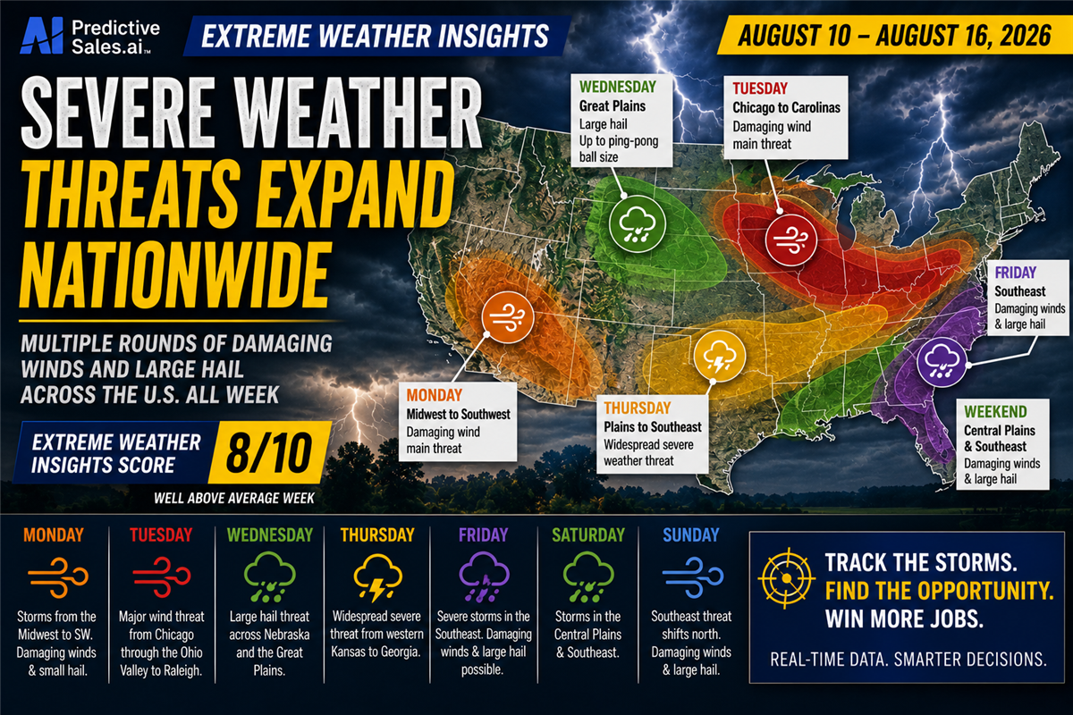
According to Dr. Gensini's latest Extreme Weather Insights forecast, the period of August 10–16 carries a score of 8/10, putting expected severe weather activity well above average. Unlike recent weeks where threats were concentrated in a few regions, this week's forecast covers a remarkably broad area of the United States, with different regions facing severe weather threats nearly every day.
Last Week: An Average Week With 800+ Hail Reports
Last week was generally close to normal for this time of year, with plenty of wind reports and more than 800 hail reports nationwide.
Of those hail reports:
156 were for hail greater than 1 inch
16 were for hail 2 inches or greater
Hail was reported across areas including eastern Iowa, central and northern Minnesota, and Kansas
Much of the activity in the eastern U.S. was driven primarily by damaging winds
Despite the additional hail activity, the overall seasonal hail trend remains concerning. The cumulative numbers have moved only slightly back toward the historical average, and the season still appears likely to finish below normal.
Dr. Gensini noted that while a record-low season does not currently appear likely, 2026 could finish among the top 10 lowest recent years for hail reports.
However, there is still plenty of storm season remaining.
The Second Severe Weather Season Is Approaching
As summer transitions toward fall, the United States enters what is often referred to as a second severe weather season.
August and September can still produce substantial severe weather activity before conditions begin to decline more rapidly during October and November.
That makes this week's significant increase in activity particularly important for contractors monitoring storm-driven opportunities.
Monday: Storms Stretch From the Midwest to the Southwest
The week is already underway with storms moving across the Midwest.
Overnight storms moved through northern and central Illinois, producing several damaging wind reports. That activity is continuing eastward into Ohio and Pennsylvania, with damaging winds remaining the primary concern.
Hail is not expected to be a major threat with these storms because warm temperatures below the cloud base are limiting hail development.
Later Monday, attention turns to a stationary boundary and cold front stretching across the central U.S. Storms are expected to develop along the boundary, with damaging winds as the primary threat.
There is also an outside chance of a weak tornado and hail up to approximately quarter-size.
The developing Southwest monsoon adds another area of interest, with portions of southern Arizona potentially seeing damaging winds and small hail.
Tuesday: A Major Wind Corridor From Chicago to North Carolina
Tuesday could be one of the week's most important days.
The primary risk corridor stretches from Chicago through the Ohio River Valley and potentially toward Raleigh, North Carolina.
The dominant threat will be damaging winds, although initial storms across Illinois and Indiana could also produce hail.
With such a large and populated corridor potentially affected, Tuesday represents a significant opportunity for contractors monitoring storm activity and impacted communities.
Wednesday: Large Hail Across the Great Plains
Wednesday shifts the focus westward.
The forecast calls for a more traditional Great Plains hail setup, particularly across Nebraska.
Hail could reach approximately ping-pong-ball size, with the threat potentially expanding farther south and east as the forecast gets closer to the event.
The risk could eventually approach St. Louis, making this another day worth watching for significant hail activity.
Thursday: A Widespread Severe Weather Threat
Thursday stands out as another major day.
A combination of strong forcing, atmospheric instability, very hot and humid conditions, and increasing wind shear could generate widespread thunderstorms.
The potential threat stretches from:
Western Kansas → Missouri → Southern Illinois → the Carolinas → Georgia
Damaging winds appear to be the primary concern, but the overall combination of ingredients suggests a substantial severe weather day.
Friday: Southeast Storms Move Toward the Florida Panhandle
Friday shifts the focus into the Southeast.
Severe thunderstorms are expected across portions of:
North Carolina
South Carolina
Georgia
Florida Panhandle
The primary threats will be damaging winds and large hail.
This continues the week's pattern of moving severe weather threats across dramatically different regions rather than concentrating activity in one area.
Weekend: More Storms Across the Plains and Southeast
Saturday brings a split risk.
One area develops across the Central Plains, extending from Iowa into Kansas.
At the same time, the Southeast remains active, with a similar threat area to Friday.
Sunday looks similar again, although the Southeast risk may shift slightly farther north.
Damaging winds and large hail remain the primary concerns.
The result is an unusually broad forecast footprint, with severe weather opportunities continuing across different parts of the country every day.
Extreme Weather Insights Score: 8/10
For August 10–16, Dr. Gensini assigns an Extreme Weather Insights Score of 8/10—well above average.
The biggest difference from recent weeks isn't necessarily one massive storm event. It's the breadth and consistency of the forecast.
Severe weather threats are expected every day, but the geography changes constantly:
Midwest → Ohio Valley → Great Plains → Southeast → Central Plains → Southeast
That means contractors in multiple markets could see opportunities from damaging wind and hail events throughout the week.
Turn This Week's Storm Activity Into Opportunity
For roofing, restoration, and other exterior contractors, a busy weather week creates more than a forecasting challenge. It creates a need to quickly understand where damage occurred and which neighborhoods were affected.
Predictive Sales AI's Extreme Weather Intelligence helps contractors monitor severe weather activity, identify impacted areas, and focus marketing efforts where storm damage is most likely.
With an 8/10 Extreme Weather Insights score, this is a week worth watching closely.
The forecast is calling for widespread activity. The next step is identifying where the storms actually hit.

Staying One Step Ahead: How Liberty Roofing Is Building for What’s Next

From WeatherHub to a Complete Marketing Partnership

Built to Evolve: How Legacy Remodeling Has Grown With Predictive Sales AI
Extreme Weather Insights: Severe Weather Season Winds Down September 21–27

Turn More Website Visitors Into Customers With the New Project Showcase Widget
Subscribe to Predictive Sales AI, LLC's Blog

Comments