Severe weather remains active across multiple parts of the country this week, but the overall setup is more typical for mid-to-late August than last week's above-average activity.
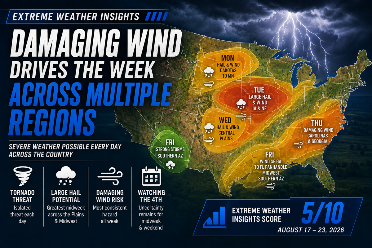
For August 17–23, 2026, Dr. Gensini gives this week's forecast an Extreme Weather Insights Score of 5/10. Thunderstorms are expected somewhere across the country nearly every day, with damaging wind emerging as the most consistent threat. Hail opportunities will be more concentrated, particularly across parts of the Plains and Midwest.
Last Week Delivered More Than 2,700 Wind Reports
Last week's 8/10 forecast focused primarily on the Central Plains and Southeast, with severe weather extending from the Florida Panhandle through the Ohio River Valley and back into the Plains. The forecast verified well, with the resulting activity following much of the expected geographic pattern.
Wind was the dominant story.
More than 2,700 damaging wind reports were recorded, along with 210 hail reports. Of those hail reports, 91 involved hail two inches or larger, with the Dakotas standing out for particularly large hail. Arizona also experienced an unusual pocket of activity that included hail and a tornado report.
Overall, Dr. Gensini characterized August 10–16 as a very active and above-average week.
A Tale of Two Severe Weather Trends: Hail vs. Wind
One of the more notable stories this season continues to be the difference between hail and damaging wind activity.
Hail remains well below average. Through this point in the year, 4,462 hail reports have been recorded compared with an expected level of roughly 5,290, and Dr. Gensini expects the year is likely to finish below average for hail.
Wind tells a very different story.
Roughly 11,000 damaging wind reports would normally be expected through this point in the year. Instead, the total has reached approximately 17,000 reports. Wind activity moved well above average in March and remained elevated through the peak severe-weather months of May, June, and July.
That contrast remains important heading into this week's forecast: the atmosphere may lack some of the stronger wind shear needed for widespread large hail and tornadoes, but there is still plenty of potential for damaging thunderstorm winds.
Monday: Plains and Upper Midwest Take the Lead
The week begins with thunderstorms redeveloping across the Great Plains.
The greatest potential for hail and damaging winds is expected across portions of Nebraska, the eastern Dakotas, and western Minnesota.
Farther southeast, another area to monitor extends across the Carolinas, northern Georgia, and eastern Tennessee. Hail is not expected to be a major concern there, but heavy rain and damaging winds are possible.
Tuesday: The Biggest Severe Weather Day of the Week
Tuesday currently looks like the most significant day of the forecast.
The primary corridor stretches along Interstate 80 across Iowa and portions of Nebraska, where storms could produce large hail and damaging winds.
For contractors and storm-response teams operating in this region, Tuesday is the day to monitor most closely as storms develop.
Wednesday: Hail Returns to the Central Plains
By Wednesday, thunderstorm activity shifts back toward the central High Plains.
A setup similar to last week's activity near Denver could produce numerous thunderstorms and considerable amounts of small hail. Damaging winds will also be possible, with the potential for some larger hail as storms move into Nebraska and Kansas.
Thursday: Damaging Wind Threat Shifts Southeast
Thursday moves the primary severe-weather focus back toward the Carolinas and Georgia.
Repeated thunderstorm development could produce strong to intense storms, with damaging wind as the primary concern. The threat is not currently expected to extend as far south as Florida on Thursday.
Friday: Three Areas to Watch
Friday brings a more complicated setup, with three separate areas showing potential for stronger storms.
In the Southeast, the damaging wind threat across the Carolinas and Georgia is expected to extend into the Florida Panhandle. Hail potential appears limited in this corridor, with damaging winds remaining the bigger concern.
A stalled cold front could also support strong to severe thunderstorms somewhere across the Midwest, although the exact location remains uncertain. Both hail and damaging winds will be possible depending on where the front ultimately sets up.
Finally, the monsoon pattern returns to the Desert Southwest, with southern Arizona seeing its best opportunity of the week for strong thunderstorms.
Weekend: Severe Weather Becomes More Marginal
The pattern should become quieter heading into the weekend.
On Saturday, western portions of the Dakotas, eastern Wyoming, and the Nebraska Panhandle could see isolated severe storms. The ingredients are relatively marginal, but storms that do develop could become severe.
A similar area could remain in play Sunday, although forecast confidence is currently too low for a more defined outlook.
What Contractors Should Watch This Week
The overall pattern is one of repeated thunderstorm opportunities rather than one major nationwide outbreak.
Key areas to monitor include:
Monday: Nebraska, eastern Dakotas, western Minnesota; Carolinas, northern Georgia, and eastern Tennessee
Tuesday: Iowa and Nebraska, with large hail and damaging wind potential
Wednesday: Central High Plains into Nebraska and Kansas
Thursday: Carolinas and Georgia
Friday: Southeast and Florida Panhandle, Midwest, and southern Arizona
Saturday: Western Dakotas, eastern Wyoming, and Nebraska Panhandle
With an Extreme Weather Insights Score of 5/10, this is a more average week overall, but damaging wind could still create meaningful storm impacts across several markets.
From Forecast to Action
Knowing where severe weather may develop is the first step. Once storms move through, the bigger question for roofing and exterior home improvement businesses becomes: Where did the weather actually hit?
PSAI Extreme Weather Intelligence helps teams track storm activity, visualize hail and wind events, identify potentially impacted neighborhoods, and turn storm data into targeted homeowner audiences.
The workflow is straightforward:
Monitor the storm → Identify impacted areas → Prioritize opportunity → Build an audience → Activate targeted outreach
That distinction matters during a week like this one, when severe weather could develop across multiple regions on different days. Instead of treating every storm equally, businesses can use weather and geographic intelligence to focus their resources where the opportunity is strongest.
Bottom Line
This week's 5/10 forecast calls for a fairly typical late-summer pattern, with thunderstorms developing somewhere across the country nearly every day.
Tuesday's hail and damaging wind potential across Iowa and Nebraska stands out as the week's most significant setup, while damaging wind opportunities will shift between the Plains, Midwest, and Southeast throughout the week.
The bigger seasonal story continues to be wind. With approximately 17,000 damaging wind reports already recorded compared with roughly 11,000 expected through this point in the year, 2026 has been an exceptionally active year for damaging wind—and that trend remains worth watching as the severe-weather season continues.

Do Call Tracking Numbers Hurt SEO?

How Contractors Use Project Showcase to Turn Completed Jobs into New Opportunities

How Mr. Roofing Turned Decades of Customer Trust into Smarter Marketing and 38% Growth

Meet the Next Evolution of PSAI: From AI Assistance to AI-Powered Action
Hurricane Isaias: 110 MPH Winds Threaten Florida Panhandle as Landfall Nears
Subscribe to Predictive Sales AI, LLC's Blog

Comments