After a highly active holiday week that brought severe weather to nearly every region east of the Rockies, the pattern remains active heading into July.
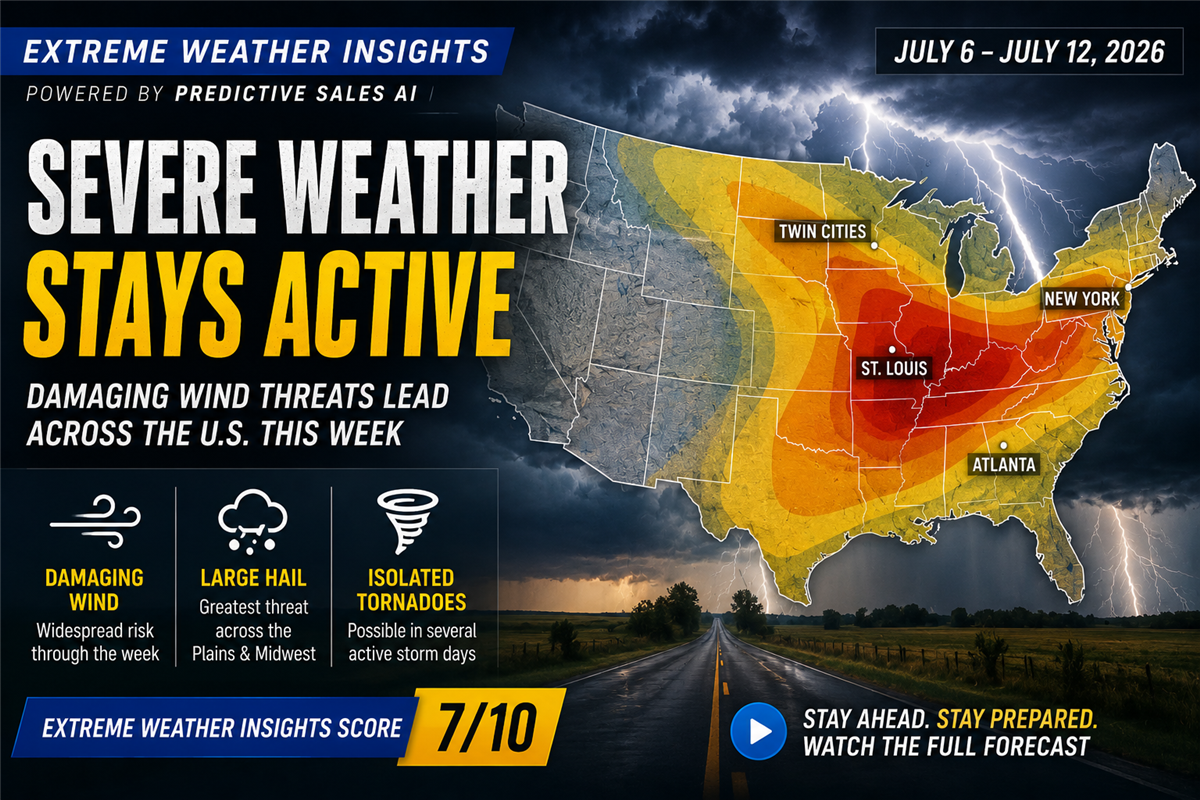
This week's Extreme Weather Insights forecast highlights another above-average stretch of severe weather, with daily storm opportunities expected from July 6–12. While activity may not reach last week's intensity, damaging winds, large hail, and several high-population markets remain in focus.
This week earns an Extreme Weather Insights Score of 7/10, signaling another active period for roofing contractors, restoration companies, and storm response teams.
Last Week: Severe Weather Covered Nearly the Entire Eastern U.S.
Last week's forecast carried an Extreme Weather Insights Score of 8/10 — and the activity delivered.
Severe storms impacted nearly every state east of the Rockies, with the strongest activity focused across the Upper Midwest, Northern Plains, and Northeast.
The biggest story continues to be damaging winds.
Last week produced:
2,800+ damaging wind reports
344 hail reports larger than quarter size
48 major hail reports exceeding two inches
Several areas experienced measured wind gusts over 80 mph, including portions of Illinois, while widespread wind reports extended across the Midwest, Southeast, and Northeast.
Although hail activity increased, the season continues to trend slightly below the 15-year average for total hail reports. Without a very active secondary hail season in September and October, 2026 may finish below average from a hail perspective.
However, damaging wind continues to create widespread storm restoration opportunities.
This Week Starts Quiet Before Activity Builds
Monday begins with a quieter setup across much of the country.
A cold front moving through the Dakotas will trigger thunderstorms across the eastern Dakotas, while isolated wind and small hail threats develop across Virginia and North Carolina.
While Monday is not expected to produce widespread severe weather, it begins a week-long pattern of daily storm chances.
Tuesday: Twin Cities Enter the Risk Area
By Tuesday, the cold front pushes farther east and brings increased severe weather potential into the Upper Midwest.
The Twin Cities region becomes an area to watch for:
Damaging winds
Hail potential
Strong thunderstorms
This same boundary will continue to influence severe weather development throughout much of the week.
Wednesday–Thursday: The Most Active Stretch of the Week
Midweek brings the strongest severe weather setup.
By Wednesday, storms are expected to develop along the stalled frontal boundary, producing the potential for:
Hail exceeding two inches
Damaging straight-line winds
Multiple severe storm clusters
Thursday currently appears to be the most active day of the week.
A large portion of the country could see severe weather, including:
Montana
Oklahoma Panhandle
Colorado
Nebraska
Iowa
Illinois
Indiana
Ohio
The Interstate 80 corridor will be a key area to monitor, with the potential for significant damaging wind events as storms organize along the stalled boundary.
Friday Brings Severe Weather Into Major Population Centers
The severe weather threat shifts east heading into Friday.
A large corridor from New York City back through St. Louis and into the Carolinas could experience storms capable of producing damaging winds and isolated hail.
While hail sizes may remain closer to quarter size in many areas, the population exposure makes Friday a potentially impactful storm day.
Markets to monitor include:
New York
Ohio Valley
St. Louis region
Mid-Atlantic
Carolinas
Weekend Pattern: Plains Hail and Southeast Wind Threat
Saturday shifts attention back toward the Plains, where hail becomes the primary threat.
Additional wind and hail risks are also expected across portions of the Mid-South and Southeast, especially around:
Eastern Tennessee
Smoky Mountain region
Carolinas
By Sunday, a similar pattern continues, with storm chances potentially extending farther south toward Atlanta and the Florida Panhandle.
What Roofing and Restoration Companies Should Watch
This week's activity is widespread, with severe weather chances nearly every day.
Key opportunities include:
Monday
Eastern Dakotas
Virginia
North Carolina
Tuesday
Twin Cities
Upper Midwest
Wednesday–Thursday
I-80 corridor
Colorado
Nebraska
Iowa
Illinois
Indiana
Ohio
Friday
New York to St. Louis corridor
Mid-Atlantic
Carolinas
Weekend
Plains hail risk
Tennessee
Southeast markets
Bottom Line
July continues the trend of active severe weather, especially when it comes to damaging wind.
While hail reports remain below historical averages, widespread wind events continue to create opportunities across some of the country's largest markets.
With severe weather chances expected every day this week and an Extreme Weather Insights Score of 7/10, roofing and restoration teams should continue monitoring storm activity closely and be ready to act as new impact areas develop.

Do Call Tracking Numbers Hurt SEO?

How Contractors Use Project Showcase to Turn Completed Jobs into New Opportunities

How Mr. Roofing Turned Decades of Customer Trust into Smarter Marketing and 38% Growth

Meet the Next Evolution of PSAI: From AI Assistance to AI-Powered Action
Hurricane Isaias: 110 MPH Winds Threaten Florida Panhandle as Landfall Nears
Subscribe to Predictive Sales AI, LLC's Blog

Comments